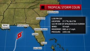
 Once off the South Carolina coastline early Tuesday morning, the system is forecast to be a 60 mph Tropical Storm before moving very quickly to the northeast, exiting our coastline by late Tuesday. Meaning that South Carolina impacts will begin later today and last through Tuesday
According to our NWS partners, the primary South Carolina threat from Colin will be the potential for heavy rainfall and associated flash flooding. A slight change in track caused the WPC to raised projected rainfall totals (depicted in the image above) to 4 to 6 inches along the coast, with isolated higher amounts. There is the potential for wind gusts to reach the 40-50 mph range along the immediate coast. The NHC still depicts no hurricane force wind probabilities with this storm. Storm surge inundation is not expected with this system. Minor coastal flooding is possible due to high astronomical tides. Tides are not directly related to Colin, but could be enhanced some tonight. Due to the lop-sided nature of this system, the greatest impacts are still forecast to be over ocean waters.
A Tropical Storm Warning is in effect from the Savannah River to the Charleston/Georgetown County line. A Tropical Storm Watch is in effect from the southern edge of Georgetown County to the northern edge of Horry County. A Flash Flood Watch is in effect for portions of the NWS Charleston coverage area. The Tropical Storm Warning and Watches mentioned are for the coastal waters. With regards to coastal counties, a tropical storm watch is in effect along the NWS Charleston coverage area. For specific forecast details related to your area, please contact your local National Weather Service Office.
