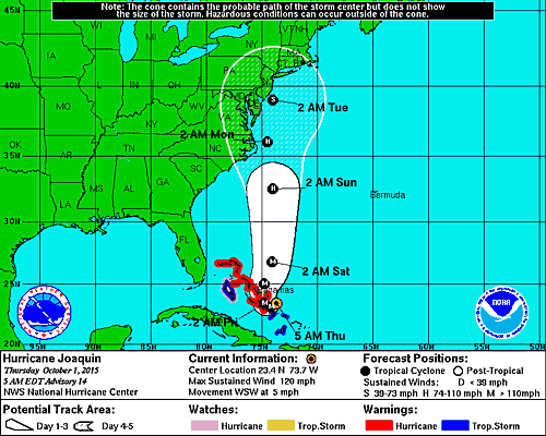
As of the 5 pm The National Hurricane Center update (Advisory 12), Hurricane Joaquin is located about 175 miles east-northeast of the central Bahamas and has maximum sustained winds of 85 mph. Joaquin is moving southwest at 8 mph toward the central Bahamas. Based on changing forecast model guidance, there is potential threat to South Carolina.
Rainfall levels may be significant for the entire coastline with the potential of wind and some surge impacts possible for northern portions of the state. This is an evolving scenario and more reliable information will be available as time progresses.
The NHC has issued Hurricane Watches and Warnings for the Bahamas. According to the NHC forecast discussion, there hasn’t been significant change in Joaquin’s structure. A southwestward motion is expected for the next 36 hours followed by a turn toward the north. There is still model disagreement in eventual track, but many of the models have shifted further west in the long range.
Given this change, the NHC has shifted the error cone to the left at the 96 and 120 hour mark which brings the center of Joaquin over the mid-Atlantic states. There is little change to the intensity forecast reasoning since the last advisory. The NHC continues to increase Joaquin’s wind speeds and peak at 115 mph (Category 3) by the 48 hour mark.
The NHC has made special notes to this advisory. They note that a hurricane watch may be issued for portions of the US coastline as early as Thursday evening. Because Joaquin is more than three days away, it is too early to talk about specific wind, rain, or surge impacts from Joaquin in the United States.
Some things to consider when planning for your family, community, church:
- Know what the evacuation routes are from your area of the State.
- Do an insurance check-up with your insurance agency of choice.
- Know where you will stay, and if you need a shelter after evacuating, download the American Red Cross Shelter Finder App at redcross.org/mobile-apps/shelter-finder-app.
- Remember not all hotels allow pets.
- Set up a communication plan for your family as well as a meeting place locally and out of town.
- Acquire first aid training and have a first aid kit on hand that you would also take with you when you evacuate.
- Develop a list of needed supplies to have at home and for evacuation, for more information see ready.gov/build-a-kit. Note some things include, prescriptions, personal hygiene needs, children and pet needs, important papers and priceless items.
- Plan to “not” have access to stores and banks. Have at least a 3-5 day supply of non-perishable food and water as well as some cash on hand. Also plan to not have full utilities such as power and water for days and possibly weeks.
- Use extreme caution when traveling after a hurricane, such as avoiding down power lines and rising floodwaters.
- Have a home inventory including pictures for possible insurance purposes, store away from your home in a safe place and consider giving your insurance company a copy.
- Don’t forget friends and neighbors that may be at a greater risk.
Precautions and Preparations:
Hurricane Joaquin is currently a category four hurricane with an uncertain track. The storm could bring dangerous rip currents, higher tides and additional rain to the coastal areas already experiencing flood conditions.
“Even if Hurricane Joaquin heads out to sea, the entire state could experience significant flooding from heavy rains that are predicted,” SCEMD Director Kim Stenson said, “We’ve already seen flooding in many parts of South Carolina, these storm systems could make conditions worse.”
We need to continue to watch this storm. It appears we are mostly in for a rain and flooding event.
Pastors and church leaders are encouraged to:
Monitor storm conditions via local media, the National Hurricane Center and the National Weather Service.
Be aware of potential flash flooding. If there is any possibility of a flash flood, move to higher ground.
If time allows, prepare your home or church for a flood by moving essential items to an upper floor, bring in outdoor furniture, disconnect electrical appliances and be prepared to turn off the gas, electricity and water.
Do not walk through moving water.
Do not drive into flooded areas.
Understand the difference between a Watch and a Warning. A Tropical Storm Watch means tropical-storm conditions are possible within 48 hours. A Tropical Storm Warning means tropical-storm conditions are expected within 36 hours.
Keep supplies in vehicles, top off fuel.
Consider the safety of pets.
If you do get flooded, notify your insurance company as quickly as possible. The longer water stays the more damage it does.
Then notify your District superintendent and District Disaster Coordinator
After the threat, do an Insurance Audit. This will help you make sure you have adequate insurance for buildings and contents. It is important to know that some things might require additional riders…such as expensive hand bells or robes. Do this annually.
For more information about the Conference disaster response program click here.
Disaster Response Coordinator:
Rev. Gregg Scott Varner
864-614-9234
gsv1003@gmail.com
